School Guide API
Use our School Guide API to add school information and catchment area maps to your website.
Since 2014, School Guide has been the first choice
for UK parents looking for clear and concise
school information. Up to 25,000 parents
rely on our data each day.
We aggregate official data on schools and package it
up in our robust API. We’ve done all the homework
on 34,000 UK schools – so you don't have to.
You can have the benefit of our research,
understanding and experience of key school
statistics by adding our comprehensive and
rigorously maintained dataset to your website.
School Guide API
We provide all the building blocks for your team to develop a fully integrated school information service on your website. Ideal for larger clients who have the resources to create the perfect, and perfectly reliable, custom solution for their users.
Our API includes:
- The latest and most comprehensive school dataset – updated weekly
- School catchment heatmap data – show your users where they need to live to get into their chosen school.
API Clients
School Guide has a proven track record of providing data for the largest websites in the UK:
Want to discuss adding School Guide's award winning school information to your website?
Email: [email protected]
Or you can reach our API Team seven days a week on 0117 370 4684
5 Reasons To Use School Guide
- We offer data that other sites (and the government) don’t publish.
- We use Plain English to explain data. Our trusted helper text comes as part of our package
- We offer unique metrics such as our School Guide Star Rating and Happiness Rating
- We can also license our award-winning infographics
- Our heatmaps are quick and easy to read. No deciphering lines and confusing measurements
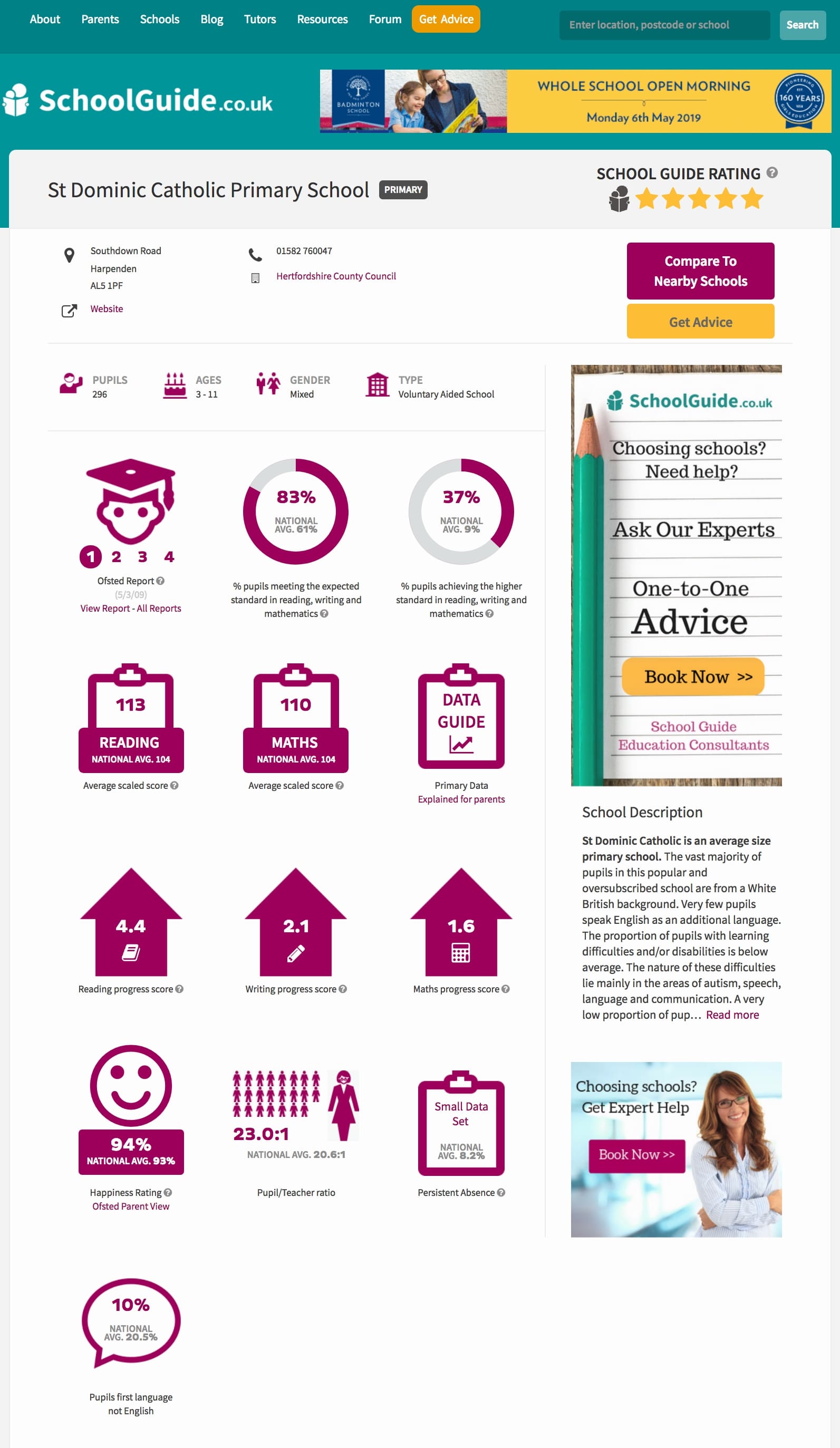
Our School Data
We collect official performance data for all UK schools. Our coverage includes primary,
middle and secondary schools, where available, in all regions i.e. England, Wales, Scotland
and Northern Ireland, in both the state and independent sector schools. All the fields we
display have been user tested to help us cut through the large volume of official data and
ensure we only offer parents the most relevant and useful data points. Labels and hovers are
clearly expressed to assist parents quickly and easily understand the meaning of each one.
Our comprehensive data set is rigorously maintained in line with official publication
schedules, updating as often as daily in the case of Ofsted reports.
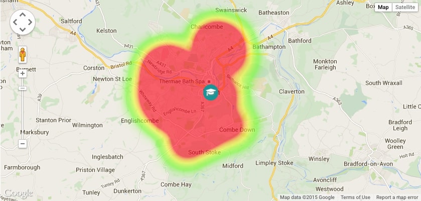
Our Catchment Maps
Our catchment API provides over 20,000 unique pupil heat maps. We do not currently collect
catchment information for independent schools. These schools may be selective and admit
pupils from a wide variety of postcodes. Coverage provided by our pupil heat maps is
extensive across all regions except Northern Ireland.
These unique maps are plotted using official pupil data taken from the last School Census
collected by the Department for Education. They visually represent where all pupils lived at
the time of the annual School Census, categorised to represent
density of pupils by using ‘many’, ‘some’ and ‘few’. School Guide offers the functionality to
enter a postcode and drop a user’s home location on the map.
Example visualisation of a pupil heat map on School Guide:
Contact Us
Email [email protected] to discuss which is the right school data solution for your
business and how we can get you started on your school data journey.
Or you can reach our Data Team seven days a week on 0117 370 4684


