School Catchment Area Explained
School Guide provides all the tools you need to understand a school catchment area and be confident on the likelihood of admission based on your home postcode. Our essential guide for parents on a school catchment area includes:
What does catchment area mean?
A school catchment area is the geographical area from which a school historically draws its pupils, usually based on the distance between the school and the child's permanent home.
In the UK, the term "catchment area" refers to the neighbourhood surrounding a school. It is the primary tool used by local authorities to manage school admissions. While some parents believe these are fixed boundaries, they are actually dynamic zones used to help decide which children are given priority when a school has more applications than available desks.
How do I find out what school catchment area I am in?
You can find your school catchment area by using a postcode-based search tool or by visiting your local authority’s website to see historical "cut-off" distances.
Your home address is the starting point for establishing a school catchment area. Even for schools that require children to pass an entrance exam or practice a particular religion, where you live and how far you need to travel to get to your chosen school can be important.
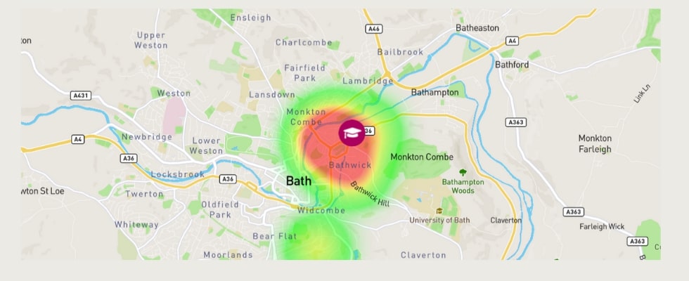
You can search for your school catchment area on School Guide by using our interactive school finder and catchment checker. This works by searching for a school and then dropping your home postcode on the catchment area heat map. These maps show where the majority of children who attend the school live and are a good indicator of likelihood of admission.
Find the best school for your child
Are school catchment areas fixed?
No, school catchment areas in the UK are not fixed geographical boundaries; they are dynamic "heat maps" that change every year based on the number of applicants.
Catchment areas can and do change each year as there are a number of important elements that affect the home address / school admission relationship. It’s important to note that there is no such thing as a line inside of which you are guaranteed to be offered a place by a school based on your address.
Each year, the edge of the catchment area is usually defined by the distance that the last pupil was offered a place at the school. If a pupil lives closer than that distance, they would have been offered a place in that year.
However, admission to a school can depend on a number of factors:
- Distance from school (catchment area) but this can be measured in different ways such as straight line or walking distance
- Special medical or social needs such as ‘looked after children’
- Siblings already at the same school
- Attendance at a ‘feeder school’ that has an affiliation with the school
- Religion
- Ability to pass an academic entrance exam (e.g. a grammar school)
Can school catchment areas change?
Yes, school catchment areas can change significantly every year because they are based on the fluctuating number of applications and the density of local school-age children in any given intake.
Because a catchment area is defined by the address of the last child to be offered a place, the "border" of that area shifts annually. If a new housing development is built nearby, or if a particular year has a "baby boom," the catchment area may shrink. Conversely, if a school becomes less popular or there are fewer children in the local area, the catchment distance may expand.
How do schools calculate the catchment distance?
Most schools calculate catchment distance using a "straight line" measurement from the child’s home to the school, though some councils use specific walking routes.
Some schools prioritise children from a specific neighbourhood and these are called a priority admission areas. But catchment areas are usually defined by the distance from the school that the last pupil was offered a place in the previous year and this can increase and decrease year on year making it impossible to set a catchment line inside which a pupil will one hundred percent gain admission to the school.
How are school catchment areas determined?
School catchment areas are determined annually by the local admission authority based on the number of applicants and the specific distance of the furthest child offered a place in the previous intake.
The determination of a catchment area isn't a pre-planned decision by a headteacher. Instead, it is the natural result of the admissions process. Once children with legal priority (such as those in care or with siblings) are placed, the remaining places are offered to those living closest to the school until the school is full. The location of that final child determines the "catchment" for that year.
What happens if a school is oversubscribed?
When a school is oversubscribed, places are allocated based on priority criteria like siblings and proximity, often causing the effective catchment area to shrink.
In the UK, if a school receives more applications than it has places, it must follow its published oversubscription criteria to decide who gets in. Usually, priority is given to "looked after" children, followed by children with siblings already at the school, and then those living closest to the school. This means that in years with high demand, the "catchment area" becomes much smaller because the available places are filled by those living just a few hundred metres away.
Do all schools have catchment areas?
While most state schools use distance as a factor, some schools like Faith or Grammar schools use different criteria like religious affiliation or exam results.
Once any criteria that come above location in the order of admissions priority are satisfied, pupils are then admitted based on where they live. There are four main ways that pupils' location can be judged:
- How far a pupil lives from a school based on a straight line
- How far a pupil lives from a school based on walking distance (this is much less common)
- Whether the school is the pupil's nearest school
- Some schools have priority admission areas that they use to only take children from a designated neighbourhood. You can find out if a school has established priority admission areas by visiting your local council admissions website.
Do grammar schools have catchment areas?
Many Grammar Schools do not have traditional catchment areas; instead, they prioritise students based on 11+ exam scores, though some may use a "priority circle" or "safe" distance for oversubscribed applicants.
Grammar school admissions are primarily academic. While a standard comprehensive school looks at where you live first, a Grammar school looks at your test results first. However, if two children have the same high score and there is only one place left, the school will then use distance (a "catchment" check) to decide between them. Some Grammar schools also have "inner" and "outer" catchment areas to ensure local children who pass the test are given preference over those travelling from further away.
How to check school catchment by postcode
The most effective way to check school catchment by postcode is to use a digital checker tool that maps out historical successful admission zones.
If you are looking for catchment area information for your chosen state school, our catchment heat maps are based on official admissions data taken from the school census. There are three main ways to check a catchment area for a school:
- Use our catchment maps to check current admission trends and likelihood of admission.
- Check with your local authority website for the most recent admission figures including whether a school has been been oversubscribed. We have a list all the local authorities and their contact details.
- Contact the school in question as they will be best placed to advise on local trends such a bulges in sibling applications. We always advise parents to contact the person responsible for admissions at a particular school before proceeding with an application. We explain more about the importance of getting school-level information in our Data sources and methodology section further down this page.
It's quick and easy to discover a school catchment area by postcode with School Guide. Our premium school pages feature catchment maps that allow you to drop your home postcode on the map and see your school catchment area.
How to get into a school out of catchment area
To get into a school outside your catchment area, you must apply as an "out-of-area" student and rely on the school having surplus places after all local priority applicants are placed.
With the best schools seeing ten or even twenty applications per place, competition for places can be fierce and some people do attempt to cheat the system. However, local authorities investigate all applications, and offers made on the basis of false information risk being made void. This will affect parents who, for example, say they are living with relatives near the first choice school or renting a secondary property solely for the purpose of an application. Valid practice for entering a school out of catchment area is church attendance for a faith school and investing in a good tutor and passing an entrance exam if academic ability is part of the criteria making the proximity to school less important.
What schools are in my catchment area?
The schools in your catchment area are those for which your home address falls within the successful admission distance based on the local authority's current allocation.
Start by searching for the school and then dropping your postcode on the interactive catchment heat map. You can see pupils who were admitted to the school based on data from the last government school census. The number of pupils currently attending is plotted in areas shaded to represent the density of numbers. This will be show the number of pupils from each family that they admitted as ‘many’, ‘some’ and ‘few’ and give you a likelihood of admission based on the spread of the pupils currently attending the school in each section of the map.
Which primary schools are in my catchment area?
You can identify local primary schools by using your council's primary admissions portal, which lists all schools where your postcode is considered a priority location.
Out of the 30,000 schools in the UK, over 16,000 are primary schools which means there is a lot more choice in terms of local school and childcare options but pressure on admissions can still be very high in areas with schools rated Ofsted outstanding and given 5 Stars by School Guide. High results in Key Stage 2 SATs are also a factor. Distance from the family home to school is generally less than for secondary schools and competition for places for siblings can be high. If you search by location or area you will see the list of the closest local options and on each of the individual school pages, you can find the primary school catchment area and drop your home postcode on the map to see your likelihood of admission. We categorise density of pupils currently attending the school in terms of number of successful catchment area admissions by three terms: 'many', 'some' and 'few'.
Which secondary schools are in my catchment area?
Secondary school catchments are often larger than primary ones and can be checked via your local authority's secondary transfer guide or an online postcode checker.
It's quick and easy to see which secondary schools you are likely to be admitted to based on the geographical criteria of your family and whether you need before or after school childcare. Start by searching by your location and selecting the 'secondary' option and you will see a list of all your local secondary schools in the area. You can then click in the secondary school pages and discover their catchment areas based on their most recent school cenusus data. It's important to note that catchment areas can and do change each year and we advise that you always check the latest admissions trends with the school or local education authority.
Find the best school for your child
Find A Primary School Catchment Area
.jpg)
You can find which primary schools are in your local catchment area and suitable for your family by searching for your first choice school and exploring our interactive catchment area maps based on density of admissions and using real time updates.
Find A Secondary School Catchment Area

You can find which primary schools are in your local catchment area and suitable for your family by searching for your first choice school and exploring our interactive catchment area maps based on density of admissions and using real time updates.
Are there different types of school catchment area?
Yes, there are different types of catchments including 'priority circles,' 'inner and outer catchments,' and 'feeder school' systems where admission is linked to a specific primary school.
Once any criteria that come above location in the order of admissions priority are satisfied, pupils are then admitted based on where they live. There are four main ways that pupils' location can be judged:
- How far a pupil lives from a school based on a straight line
- How far a pupil lives from a school based on walking distance (this is much less common)
- Whether the school is the pupil's nearest school
- Some schools have priority admission areas that they use to only take children from a designated neighbourhood. You can find out if a school has established priority admission areas by visiting your local council admissions website.
Why are School Guide's catchment area maps the most reliable?
School Guide maps are highly reliable because they use official government data to plot the exact locations of pupils who were successfully admitted in previous years.
School Guide's heat maps are the original UK school catchment heat maps, developed in 2015 by a team of highly skilled data analysts and website engineers. We have exclusive access to Department for Education data to create these maps and offer the best catchment indicator tool to UK parents.
Do you have to pay to access a catchment area maps?
No, we offer free access for up to three heat maps for your chosen schools so that cost is never a barrier to parents accessing information on school catchment information. Please email [email protected] with your request. Kindly note: you will be sent static images of maps which are not interactive but give you a good indication of the areas around each school that admitted many, some, few and no pupils in the last academic year.
Data sources and methodology
School Guide catchment maps are powered by official statutory census data, including the National Pupil Database (NPD) in England, the Pupil Level Annual School Census in Wales, and the Pupil Census in Scotland.
School Guide is home to the original catchment heat maps, developed with exclusive government pupil data to help parents quickly and easily view their likelihood of admission to a school based on their home postcode.
Official pupil data is taken from the last government school census and is used to create a simple visualisation of where all pupils attending the school lived at the time of the census. Our unique heat maps offer a guide to the areas from which the largest groups of children attend and, for many schools, can be a useful indicator of catchment area. Parents can drop a pin with their home postcode on the heat map and see the level of density of admissions from that exact spot. School Guide’s heat maps show there areas from where ‘many’, ‘some’ and ‘few’ pupils were admitted to the school in the most recent data year. This can help parents understand the likelihood of admission to a school based on geographical criteria.
Find the best school for your child
England
We have used pupil-level data from the School Census which is collected and subsequently made available through the NPD request application process by the Department for Education. For further details, please see Important information about the School Census below.
General admission data is based on a set of geographical areas called Output Areas (OAs). An Output Area is the lowest geographical level at which census information is provided and is therefore the most detailed and accurate data available. The minimum OA size is 40 resident households and 100 resident people but the average size is around 125 households. This takes into account areas of less dense population and ensures individual postcodes cannot be identified. Our maps combine pupil data from each state-funded school with groups of local postcodes or OAs. See the Office for National Statistics for more information on Output Areas.
Important information about the School Census
The
School Census
is a statutory census that takes place during the autumn,
spring, and summer terms. Once collected, pupil-level data from the School Census
is held in the National Pupil Database (NPD). The NPD holds detailed information
about the educational establishments children attend, their achievement and
progression at different key stages, their individual level characteristics
including gender, ethnicity, eligibility for FSM and information about Special
Educational Needs. The NPD also includes a range of other information including
detailed information about pupil absence and exclusions. To request extracts
of the NPD a requester will need to complete the NPD data request application
form and an information security questionnaire. Decisions on whether data can be released
are subject to a robust approval process and are based on a detailed assessment of who
is requesting the data, the purpose for which it is required, the level and sensitivity
of data requested and the arrangements in place to store and handle the data.
To be granted access to extracts of the NPD requestors must comply with strict terms and
conditions covering the confidentiality and handling of data, security arrangements,
and retention and use of the data.
We currently display School Census data from 2025. School Guide’s heat maps contain statistical data from the Office of National Statistics (ONS) which is Crown Copyright. The use of the ONS statistical data in this work does not imply endorsement of the ONS in relation to the interpretation or analysis of the statistical data. This work uses research datasets which may not exactly reproduce National Statistics aggregates.
Wales
We use pupil data collected as part of the Pupil Level Annual School Census published by the Welsh Government in 2025 (released annually). Our maps combine actual pupil data from each state-funded school with groups of local postcodes or Lower Super Output Areas (LSOAs). There are 1,910 LSOAs in Wales each with a population of around 1,500 people. Information relating to LSOAs that include small pupil numbers may have been suppressed.
Scotland
We use pupil data from the Pupil Census published by the Scottish Government in 2025 (released annually). Our maps combine official pupil data from each state-funded primary and secondary with groups of postcodes called data zones. There are 6,976 data zones in Scotland which nest within local authority boundaries and have a population of between 500 and 1,000 household residents.
School Guide is aware that in Scotland the majority of school places are allocated by the Local Authority and not via stated preference.


